Dynamic Processes of the Earth
According to the CSET website, the multiple choice part of the exam has 15 questions for the domain, Dynamic Processes of the Earth. There is also one Constructed Response Question.
Click on the link to jump straight to that subcategory:
Tectonic Processes and Features
Rock Formations
Shaping Earth's Surface: Surficial Processes and Features
Energy in the Earth System
Tectonic Processes and Features (SMR 2.1)
a. Diagram the features that provide evidence for plate tectonics.
The Theory of Plate Tectonics first begins with the meteorologist and geophysicist, Alfred Wegener. Wegener proposed that all continents were once joined together at one point called Pangaea (Pan=all Gaea=Earth). Wegener hypothesized that Pangaea began to split apart during the Mesozoic Era (approximately 200 million years ago). He proposed a hypotheses called Continental Drift to explain this idea.
There are four main evidence for his hypothesis that he came up with:
1) Puzzle Fit of the Continents: Some scientists argued that it is a very crude fit so they set out to see how the continents fit together. They discovered that you can get a much better approximation of the actual boundary of the continents if you look at their continental shelf as a boundary line. While some areas overlap, such as the west coast of middle Africa, the pieces of the continents fit better than some of the scientists expected.
2) Fossil Evidence: Wegener learned that identical fossil organisms were found on both Africa and South America. One type of fossil organism, the reptilian mesosaur, was found in Eastern South America and Africa. Wegener thought, if the creature could travel across the vast Atlantic Ocean, then it should also be able to have traveled to various other regions. In other words, it's remains should be more widely distributed. Another fossil used as an example for the fossil evidence was the glossopteris. This plant fossil, with large seeds, was found in regions such as Africa, Australia, India, and Antarctica. Wegener learned that these seeds only grew in subpolar climate.
3) Rock Types and Structural Similarities: Wegener noticed that if you fit the continent puzzle pieces together, mountain rages and rock types continued from one continent to the next. For example, the Appalachian Mountain Range extends fluidly from Eastern America to Western Africa, Greenland, British Isle, and into Scandinavia.
4) Paleoclimatic Evidence: As a meteorologist, Wegener was fascinated to learn that ice sheets covered extensive areas of the Southern Hemisphere and India. Layers of glacially transported sediments were found in India, South Africa, South America, Australia, and India. Much of the glacial evidence lies within 30 degrees of the equator.
Wegener received much criticisms for his hypothesis. One very large issue with his hypothesis was that Wegener was unable to provide the mechanism for his continental drift idea. How are the continents moving across the globe?
About 20 years after Wegener's death, two new types of evidence appeared to help understand how the Earth worked.
1) Paleomagnetism- aka fossil magnetism. The Earth has a magnetic north and a magnetic south pole. You can think of the Earth as having a magnetic bar, with magnetic fields passing through the planet, extending from one magnetic pole to the other. Certain rocks contain iron-rich minerals, such as magnetite, that allows it to be used as a "fossil compass". These iron-rich rocks are abundant in lava flows of basaltic composition. When heated above a certain point known as the Curie point, the rocks lose their magnetism. When they cool, the minerals would become magnetic again and would freeze in the direction of the existing magnetic poles. As these rocks moved, they still retained their magnetic alignment and are said to possess paleomagnetism. Thus, rock magnetism provides us a record of its direction and distance from the magnetic poles during the time they became magnetized again.
Vine-Mathews-Morey hypotheses connected the two hypotheses, seafloor spreading (described next) and geomagnetic reversals. Geophysicists were beginning to accept the idea that over periods of hundred of thousands of years, the Earth went through periods of magnetic reversal where the north magnetic pole became the south, and the south the north. Thus, as the crust moved, and the rocks recorded the magnetic history, it would do the same when the Earth went through its geomagnetic reversal period. Rocks that exhibit the same magnetism as present is said to possess normal polarity. Rocks that have the opposite are said to have reverse polarity. Vine and Matthews explained that as the magma solidified with the existing magnetic field, it would slowly increase in width as more crust formed as a result of the seafloor spreading. As this new crust formed, the two parts of the old crust would be carried in opposite directions.
2) Seafloor Spreading- there was a discovery made of the oceanic ridge system that wound its way through all the major oceans. Using the newly discovered facts, Harry Hess quickly came up with the hypothesis of seafloor spreading. He described that the oceanic ridges were located above areas of convective upwelling in the mantle. As this material rises and spreads, it carries the seafloor along, similar to a conveyor-belt. As the seafloor moved away from the ridge, new oceanic crust would move up through to replace it. Hess also described how the older portions of the seafloor would descend back into the mantle.
Tuzo Wilson was a Canadian geologist who provided the missing puzzle to help formulate the theory of plate tectonics. He explained that there were large faults that ran through the Earth's out shell, that divided it into "rigid plates." He also described three different types of plate margins:
1) Oceanic Ridges: plates are moving apart
2) Deep-ocean ridges: plates move together
3) Transform faults: plates slide past each other
Eventually, continental drift and seafloor spreading were combined into a theory known as Plate Tectonics.
b. Summarize the thermal processes driving plate movement.
Researchers generally agree that the convective flow within the mantle is the underlying driving force for plate movement. The warm, buoyant rock rises while the cooler, denser rock sinks down. This slow movement is a result of the uneven heating within the Earth's interior. The driving force being the subduction of cold, more dense oceanic lithosphere within the mantel. This cold lithosphere provides cold material, thus driving the thermal process. However, scientists are still uncertain as to how exactly the mantle convection flows work.
One hypotheses is the whole mantle convection model. In this model, cold oceanic lithosphere plate sinks deep within the mantle, while hot, buoyant plumes transport heat towards the surface. Problem with this model is that all chemicals would mix within time, which would eliminate chemically distinct magma. We know that our earth's mantel is a heterogeneous mix, whereas with this model, it would be a homogeneous mix.
Another model is the layering at 660 kilometers. In this model there is a thin convective layer in the upper mantel and a thicker layer below. This model affirms the fact that we have different magma compositions (with the mid-ocean ridge basalt coming from the upper convection layer and the hot spot coming from the lower convection region) However, the problem with this model is that studies of earthquakes have fount that the cold oceanic lithosphere are sometimes subducted deep into the mantle. This would mix the upper and lower layers.
The third model is the Deep-Layer Model and favors layering deep within the mantle. The lower layer acts like a lava lamp, with a slow swelling and sinking pattern without much mixing with the upper layer. In addition, this model also supports the deep subduction of the cold oceanic lithosphere.
c. Explain how density and buoyancy are related to plate tectonics
Buoyancy is the upward force cause by a fluid and is the result in the differences of densities. The driving force of plate tectonic involves the less buoyant, denser cold oceanic lithosphere to descent beneath the less dense, more buoyant continental plate.
Within the mantel the differences in density is the result of the temperature variations. Thus, the warm magma expands becomes less dense and rises. The cool magma contracts, becomes more dense, and sinks. (this process of warm rising and cold sinking is known as convection). However, regardless of which convection model type, more buoyant, hotter rock material slowly rises and less buoyant cooler material slowly sinks.
As this movement takes place within the mantel, the lithosphere is being dragged. Eventually, the lithosphere is dragged back underneath the surface. Oceanic plates are subducted back into the mantel and “disappears”. Continental plates are too buoyant to be subducted like oceanic plates and instead are eroded down. Eventually, continental plates becomes sea-floor sediments, which will then become subducted back into the mantel.
d. Describe the types of plate boundaries
Tectonic plates move about the Earth, with their boundaries interacting with other plates'. There are three types of boundaries (each plate interacts with another plate using a combination of these types of boundaries):
1) Divergent boundaries: Involves two plates (continental or oceanic). These are located along the oceanic ridges. They are considered to be constructive plates margins as this is where new oceanic crust (lithosphere) is formed. These boundaries are also known as spreading centers. The hot magma rises and creates the oceanic crust that is less dense than the surrounding cooler rocks. It takes approximately 80 million years for the rock to finish cooling and contracting. The cooling of the rock results in it strengthening and becoming thicker. Divergent boundaries can also be found on the continent as well and begins with the formation of a continental rift. The East African Rift is an example of a continental rift at its initial stage.
2) Convergent boundaries: One might wonder, if new crust is being formed at the ridges, is our planet growing? It is not. What is happening is that older, denser oceanic lithosphere descends back into the mantle at the convergent boundary. This boundary is also known as destructive plate margins since crust is being destroyed. At these convergent boundaries, you have two plates moving toward each other, with one being forced under the other. Thus, these boundaries are also known as subduction zones. What determines which plate is subducted is its density. The plate that is more dense will be subducted. For example, if an oceanic lithosphere meets up with a continental lithosphere, it is always the oceanic that is subducted because they are much more dense then the continental lithosphere. The angle of descent varies, but is typically at 45 degrees and depends on its density. Warm, young, and buoyant lithosphere will descent at an angle that is small. These regions will experience great Earthquakes. The very old, very dense oceanic lithosphere will descend at an angle approaching 90 degrees. Convergent boundaries can take place between oceanic and continental lithospheres, between two oceanic plates, and between two continental plates- each with different outcomes.
Oceanic and Continental Convergence: As mentioned earlier, the more dense oceanic crust will descend beneath the less dense continental crust. As this oceaninc crust descends, it causes the mantle rock to melt. The wet, oceanic rock melts at a substantially lower temperature than dry rock as it moves into this high-pressure environment. As the crust continues to be subducted, its water is "squeezed" out. At great depths, heat, and pressure, the water leads to partial melting. This molten material is less dense so it rises towards the surface. This may give rise to volcanic eruption. In some cases, an oceanic plate also contains continental crust.
Oceanic and Oceanic Convergence: Has many features similar to the oceanic-continental plate margins, with one of the main differences being the crust capping the overriding plate. When two oceanic plates converge, one of them descends beneath the other. This action initiates volcanic activity. Just like in oceanic-continental boundaries, the water is "squeezed" out from the plate that is being subducted, which triggers melting. The volcanoes grow from the ocean floor (versus from the continental in a oceanic-continental convergent boundary). If the subjection continues, then a chain of volcanic structures can emerge as islands. As the plate moves, the chain of islands are built up and spaced out about 80 km apart. This formation is known as a volcanic island arc. The Aleurtian islands is an example of an island arc formation.
Continental-Continental Convergence: In the Oceanic-Continental Convergent plate margin, as the oceanic plate is subducted beneath the continental plate, the plate is forced further along, the continental crust collides with the continental plate. Since both are similar in density and buoyancy, the result is a formation of mountain range. The Himalayas, Alps, and the Appalachians are just some examples of mountains systems that were formed in a continental collision. However, before this continental collision takes place, between these two continental landmasses, there is an ocean basin.As subduction is taking place, volcanic island arc may form. As the oceanic plate is subducted, and the continental landmasses collide, it the new mountain range will also be composed of the deformed and metamorphosed sedimentary rocks from the volcanic arc.
3) Transform boundaries: This boundary involves two plates moving past each other without the formation or destruction of lithosphere. Most transform boundaries are located within the ocean basins. Some transform faults join two segments of mid-ocean ridge. Transform faults can also be connected to the spreading centers and help transport oceanic crust to the destruction site, at a deep-ocean trench. Or, transform faults can be found to cut through continental crust, such as the San Andreas Fault or the Alpine Fault in New Zealand.
e. Relate the causes of volcanoes, earthquakes, and earth resources to tectonic processes
Volcanoes-as a slab of oceanic lithosphere subducts beneath the continental plate, it causes the mantle rock to melt. The “wet” oceanic rock in a high pressure region has a lower melting point. Partial melting of mantle rock produces basaltic rock material. This type of magma produces less viscous, mafic magma that produces mild eruptions (such as the Hawaiian volcanoes). Most volcanoes are located along the margins of the ocean basins especially in the circum-Pacific belt (aka Ring of Fire).
In a continental setting, the basaltic magma melts and assimilates some of the surrounding crustal rocks as it penetrates further down. This produces silica rich magma that is more viscous and contains more gas and water. This produces explosive eruptions.
Volcanoes can also form from hot spots. Volcanism occurred as the tectonic plate moves over a hot spot (a region where mantle plume melts in a low-pressure environment. As the plate continues to move over the hot spot, successive volcanoes are built.
There are four different types of volcanoes:
Composite Cone: Also known as stratovolcano. This type of volcano is composed of both lava flows and pyroclastic material. It is very picturesque, but also potentially dangerous. Most of these types of volcanoes are located in a relatively narrow zone that rims the Pacific Ocean (Ring of Fire). The classic composite cone is large and nearly symmetrical. it is felsic, generates thick viscous lava that travels short distances. Has a 5-6% gas content and explosive. Examples include Mt. St. Helen, Mt. Rainier, Mt. Shasta (one of the largest composite cones in the Cascade Range) and Mt. Garibaldi. The growth of a typical composite cone begins with both pyroclastic and lava spewing forth from the central vent. Overtime, the lavas flows from the fissures that develop on the lower flanks of the cone and alternates with the explosive eruptions that ejects pyroclastic material from the summit crater. Sometimes both occur simultaneously.
Cinder Cone: Also known as scoria. These are small volcanoes built out of ejected lava fragments that consist mostly of small, pea size lapilli. Cinder cones are the most abundant type of volcano. They are steep and have large, deep craters. Like composite, they also tend to be relatively symmetrical although many cinder cones are elongated and higher on the side that was downwind during an eruption. They are fast forming, with 95% being formed in less than one year. They have a short life span. This is due to the fact that once the eruption event ceases, the magma in the vents begin to solidify. They are viscous, has a 5% gas content, and are explosive. These are found all over the world. Mount Etna, Parícutin are just two examples.
Shield Volcano: These types of volcanoes are broad, gently sloping, built from basaltic lavas, non viscous, has a 1-2% gas content, and non-explosive. The shape resembles somewhat of a warrior's shield, hence its name. Most shield volcanoes have grown from deep ocean floor to form islands. Other shield volcanoes form on continents. The lavas are discharged from the summit vents as well as rift zones that develop along the slopes. Examples include Mauna Loa in Hawaii, Skjaldbreiður in Iceland, and Newberry in Oregon.
Dome: This type of volcano is felsic, viscous, has a 2-4% gas content. Lava flow is thick and sticky so it tends to pile up around the vent. Mt Lassen is an example.
The property of a magma that determines whether or not it has high viscosity is its silica content. High viscosity= high silica content = more explosive the volcano will be when it erupts. Felsic magma has a relatively high silica and low iron and magnesium content. Felsic magma will crystalize to become rhyolite. Intermediate composition magmas will crystallize to produce andesite.
On the other hand, low viscosity= low silica content= less explosive. Mafic magmas has a relatively low silica and high iron and magnesium content. Mafic magma will cool and crystallize to produce the volcanic rock called basalt. Mafic rocks tend to be darker in color than felsic because they are enriched in iron and magnesium.
Earthquakes- Earthquakes are a result of energy being released within the earth, either from volcanic activity (due to either gases or magma rising up through the volcano) or slippage along a fault, the most common source. Because slabs of Earth's lithosphere are in constant slow motion, plates are in constant interaction with each other. Straining and deformation along fault zones causes continuous earthquakes. For example, in a transform plate boundary, as two plates slide past each other, the rocks are bending and storing elastic energy. Eventually when one weak point slips and releases strain, the deformed rock “snaps”, which causes earthquakes.
Mineral resources are closely related to the rock cycle. The plate tectonics theory helps us to understand where and how mineral resources are produced. Metals such as gold (Au), Silver(Ag), Copper (Cu), Mercury (Hg), lead (Pb), Platinum (Pt), and Nickel (Ni) were created by igneous processes.
Igneous-As magma cools, minerals within this magma body cools and settles. Different minerals settle out and segregate at different temperatures, known as magmatic segregation. Hydrothermal deposits result from hot, metal rich fluids that are remnants of magmatic process. Liquids and metallic ions accumulate near the top of the magma chamber. Au, Ag, and Hg are produced through this process.
Metamorphic- Many of earth's resources are also produced by contact metamorphism. Rocks are chemically altered and recrystallized by the heat, pressure, and hydrothermal solutions. Common metallic minerals produced from contact metamorphism are sphalerite, galena, chalcoyprite, magnetite, and bornite. Regional metamorphism, which takes place within convergent plate boundaries, involves materials subjected to be altered by the high temperatures, high pressure environments. Chalk and graphite are produced in this environment.
f. Summarize earthquake processes in terms of epicenter, focal mechanism, distance, and materials, and the role various factors play in the amount of damage caused by an earthquake.
An Earthquake is a vibration of Earth produced by the release of energy (for example in the slippage of a transform boundary, vertical displacement in the forms of waves, horizontal movement). This energy radiates out in all directions from the focus (source) or hypocenter. The epicenter is the location on the Earth's surface, directly above the focus.
The shaking of the ground causes liquification of the soil causing damage to buildings and structures, power, and gas lines. Earthquakes produce vertical and horizontal ground motion.
Seismographs indicate that there are two main types of seismic waves. One of the waves, surface waves (L), travel along the outer part of Earth. Waves that travel through the Earth are called primary (P) and secondary (S) waves. P waves are “push-pull” waves (compress and expand). S waves “shake” the materials at right angles to the direction of travel. Since gases and liquids do not respond elastically to changes in shape, S waves are unable to pass through. Surface waves move in an up-and-down and side-to-side motion (which is very damaging to the foundation of structures). P waves arrive first at a recording station, then S waves, then surface waves. These waves travel at different speeds because each waves behaves differently as it travels through the earth.
Differences in density and elastic properties influence the velocity. Each wave also has different amplitudes, thus causing the greatest destruction. S waves amplitude are a bit less than L waves and P waves are the weakest. The difference in velocity between P and S waves helps scientists to determine the location for the epicenter.
Destruction from an earthquake can also be affected the they magnitude of the quake and its distance to a populated area. Destruction can also be based on how the buildings were constructed. The amount of structural damage will be based on the intensity and duration of the earthquake Also, the nature of the material upon the structure rests, and the design of the structure. Soft ground will aplify the vibrations more than a solid bedrock. Thus an earthquake that takes place in a city located over a firm foundation of granite will suffer less damage than one above a soft, unconsolidated sediments.
Rock Formations (SMR 2.2)
a) Diagram and Explain the rock cycle
The rock cycle has no beginning and no end. The rock cycle describes the process by which rocks are formed, decomposed, eroded, transported, and altered. The mechanism behind the rock cycle is the energy from Earth's internal heat and from the Sun. The rock cycle is tied to the tectonic cycle.
Rocks are grouped as either igneous, sedimentary, or metamorphic.
Igneous Rocks
As the magma from within the Earth begins cooling, crystals begin to form. Intrusive (forms within the earth, also referred to as plutonic) igneous rocks may consist of crystals that are either porphyritic (consists of at least two minerals with very differing crystalline sizes) or phaneritic (crystals large enough to be seen by the naked eye).
Igneous rocks also form extrusively (volcanic). These rocks form aphanitic crystals (crystals too small to be seen) due to the fast cooling of the magma. The crystals did not have enough time to develop.
Intrusive igneous rocks may undergo upheaval due to tectonic activity and become exposed due to weathering and erosion. One amazing place to see very old, ~3 billion year old rocks is an area along the Beartooth Highway at the Montana/Wyoming border. Another great place is the Stillwater Complex in Montana (which is where I was able to find 2.7 billion year old igneous rocks!) Both regions underwent tectonic activities, that resulted in the plutonic igneous rocks to be uplifted.
Examples of igneous rocks includes: pumice, granite, diorite, gabbro, rhyolite, andesite, basalt, obsidian, and quartz.
Sedimentary Rocks
Chemical and mechanical weathering break down the rocks.
Mechanical weathering: rocks that are broken into smaller pieces through physical forces such as frost wedging, biological activity, expansion from unloading, and thermal expansion. Mechanical weathering does not alter the chemical makeup of the rock, however, it does aid in the chemical weathering by increasing the surface area.
Chemical weathering: transforms the rock into one or more new compounds. The major processes for chemical weathering includes dissolution (dissolves in water), oxidation (reaction the rock comes into contact with oxygen), hydrolysis (reaction of any substance with water)
Particles, called sediments, collect in areas such as oceans, lakes, and rivers and undergo lithification (process where sediments harden into rock). The sediments are either compacted or cemented as percolating water fill the pores with mineral water. This lithification produces sedimentary rocks.
Examples of sedimentary rocks includes: shale, sandstone, limestone, chert, chalk, dolostone, coal, gypsum,
Metamorphic Rocks
Sedimentary and igneous rocks may become buried deep within the Earth or involved in mountain building and may undergo heat and pressure. This changing environment may cause the rocks to become a metamorphic rock. If metamorphic rocks are subjected to more heat and pressure, it may melt and become magma again.
Examples of metamorphic rocks: marble, quartzite, slate, gneiss, hornfels, schist, phyllite
Other paths in the rock cycle may occur, such as metamorphic rock undergoing weathering and erosion and breaking down into sediments. Sedimentary rocks may also undergo weathering/erosion and become sediments again.
Quick Quiz!
Which of the following is an example of a sedimentary rock?
a) marble
b) granite
c) limestone
d) quartz
Correct Answer: C Sedimentary rocks forms when preexisting rocks undergo weathering, are transported, deposited, and undergo lithification. Limestone is a type of sedimentary rock that is composed of marine shell mineral calcite. In option A, marble is an example of a metamorphic rock. In options B and D, granite and quartz are both an example of an igneous rock.
b) Describe relative and absolute dating techniques, including how half-lives are used in radiometric dating
Relative dating- This is a method of placing events that occurred in a sequence or order without knowing their age in years. This method was done before a reliable method of numerical dating had been established. This method is done by applying the following principals:
1) Law of Superposition- states that layers of sedimentary rock or lava flows are in layers with the oldest on the bottom, youngest on top. Nicolaus Steno (17th century) is credited as being the first to recognize the sequence of historical events in the rock layers.
2) Principle of Original Horizontality- states that layers of sediment are generally deposited in horizontal position. So, the rock layers that we see in the Grand Canyon have not been disturbed as they are still in horizontal layers. However, if we see a folded or inclined layer of rocks, then we can assume that they were moved into that position by crustal disturbances after the sediments were laid. Nicolaus Steno is also credited for recognizing this principle as well.
3) Principal of Cross-Cutting Relationships- If we see a fault line cut through rocks or a magma intrusion or a dike, then we can assume that these two events took place are younger than the rocks affected.
4) Inclusions- these are fragments of one rock unit that has been enclosed within another. The rock mass adjacent to the one containing the inclusions must have been there first in order to provide the rock fragments.
Unconformities:
When we observe layers of rock that have been deposited that have not undergone any interruptions, we call them conformable. However, throughout Earth's history, layers of sediments have been interrupted. A period during which deposition has ceased, erosion removed previously deposited rocks, and then deposition resumed is called an unconformity. There are three types of unconformities:
Angular Unconformity: these consists of a tilted or folded sedimentary layer of rocks that are overlaid by younger, flat-lying rocks. These formations show that there was a period of deformation that occurred. Very easy to recognize.
Disconformity: more common, but less conspicuous and most are difficult to identify. This is because the rocks above and below are similar and there is little evidence that erosion took place. The strata above and below the erosion surface are parallel. The sedimentary strata are relatively undisturbed below and above the erosional surface.
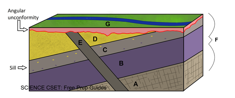
In the above illustration, we can apply our knowledge of laws and principals to understand the proper sequence of the rocks and the events.
1) We can apply the law of superposition. Layers A, B, D were deposited in that order, from oldest to newest.
2) Layer C is a sill (an igneous intrusion). We know that this event took place after layers B and D were deposited because there are fragments from layers B and D embedded in the sill.
3) Using our knowledge on the principal of cross-cutting relationships, we know that the intrusion of dike E took place after layers A, B, D and the sill E occurred as it cuts through all of these layers.
4) Next, the rocks were then tilted, event F, and erosion took place. We know that the tilting took place first as there are sections of the beds that have been eroded. The tilting and erosion was followed by more deposition, layer G. These events produced an angular unconformity.
Absolute Dating- uses a numerical number to date when the event took place or how old the object is. Absolute dates are found by using radioactivity, called radiometric dating. Radioactivity is the process where nuclei spontaneously break apart (decay). During radioactive decay, the nucleus of the unstable atom loses energy.
An unstable isotope is called a parent, and isotopes resulting from the decay of the parents are called daughter products.
There are three common types of radioactive decay:
1) alpha particles: composed of 2 protons and 2 neutrons. The emission of an alpha particle means that the mass number of the isotope is reduced by 4 and the atomic number is reduced by 2
2) beta particle: electron that are given off from a nucleus. The mass number stays the same, but the atomic number increases by one -since there are more protons than electrons now
3) electron capture: an electron is captured by a nucleus. The electron combines with the proton and forms a neutron. The mass number remains unchanged, however the nucleus now contains one less proton so the atomic number decreases by 1. The time required for half of the nuclei in a sample to decay is called the half-life of the isotope. When the quantities of parent and daughter are equal (ratio is 1:1) then we know that one half-life has transpired. When the ratio is 1:3, then two half-lives have passed. When the ratio is 1:7, then three half-lives have passed and so on.
Quick Quiz!
Who made the first clear statement of the law of superposition? When?
a) William Smith, 18th century
b) John Stuart Priestly, 19th century
c) John Wesley Powell, 19th century
d) Nicolaus Steno, 17th century
Correct Answer: D
c) Compare uniformitarianism and catastrophism
Catastrophism was an idea founded by Ussher, an Anglican Archbishop. He constructed a chronology of the Earth's history. He determined the age to be a few thousand years old, having been created in 4004 B.C. In order to fit all of Earth's landscape formations and features, such as mountains and canyons, catastrophists explained that these features were created by unknowable causes that produced worldwide disasters that created these features suddenly.
In contrast, uniformitarianism, proposed byy James Hutton, states that the “physical,chemical, and biological laws that operate today have also operated in the geologic past.” In other words, the forces and processes that are presently shaping our Earth have been working for a very long time. However, it is important to understand that the geologic process that were operating in the past may not be operating precisely at the same rate.
In contrast, uniformitarianism, proposed byy James Hutton, states that the “physical,chemical, and biological laws that operate today have also operated in the geologic past.” In other words, the forces and processes that are presently shaping our Earth have been working for a very long time. However, it is important to understand that the geologic process that were operating in the past may not be operating precisely at the same rate.
Shaping Earth's Surface: Surficial Processes and Features (SMR 2.3)
a. Describe the dynamic processes of erosion, deposition, and transport
Erosion: First of all, let's just clarify the difference between weathering and erosion. Weathering is the actual act of breaking down rocks into smaller sediments through chemical or physical means. Erosion is the actual movement of the sediments away from the rocks that are being weathered. This may occur as a result of wind, running water, ice, gravity, and/or ocean wave action. Erosion may take place very slowly, such as the movement of an ice sheet. Or, it may be very rapid, such as in a flood, such as the one that took place at the Camas Prairie Basin in Montana when an ice dam broke.
Transport: Transport is the movement of the sediments from one location to another. Wind, running water, ice, ocean waves are all methods of transporting sediments. Just like erosion, transport can occur quickly (running water) or slowly (glacial ice).
Deposition: Eventually, the sediments that are being transported are deposited. Sediments are deposited when the transporting agent's energy level drops. Sediments that are deposited forms land forms overtime. Different transporting agent creates different types of land forms. For example, wind may transport sediments that may eventually form dunes. Glacial ice transports sediments that forms hills called moraines.
b. Describe coastal procesess including beach erosion and natural hazards
On my last geology trip to Cape Disappointment, I learned just how powerful the effects of waves can be on transforming and changing the coastal region.
Coastal processes: Coastal processes includes waves, currents, incoming rivers, wind. Waves play a major role in changing the coastal system. Wind-generated waves are created by wind blowing over the ocean water. As the wind moves over the water, it creates friction and pressure, dragging and moving the water forward, creating waves.
Winds deposit sediments forming dunes.
Hydraulic action is the direct impact of waves on the coastal land.
As a turbulent layer of water approaches the shore after the wave has been broken, it carries sediments to the beach in a process called swash.
As the waves retreats, it carries some of the sediments back called backwash. On beaches where wave action is very high, you'll find larger particles. And vice versa, where wave action is low, you'll find finer grained particles.
Longshore drift carries sediments parallel along the shoreline, forming sand spits. A sand spit is the linear accumulation of sediments that is attached to the land at one end. Spits may extend across the bay, but waves usually moving across picks up the sediments and carries it away. However, if a spit does extend across the Bay and connects to the other side, then you have a baymouth bar. When the bay becomes closed off, then you have a lagoon.
Coastal Erosion: wave erosion can undercut shorelines to produce coastal cliffs. Sea caves may form when waves erode and attacks a weak zone in the rock. When the sea cave is broken all the way through, then you have a sea arch. And when sea arches collapses, then its remains are referred to as sea stack.
Natural Hazards: One of the hazards of coastal erosion is coastal landslide as a result of waves undercutting the shorelines. Human activity may also trigger a coastal landslide.
Another coastal hazard are hurricanes. Hurricanes can result in flooding and bring heavy rain and wind.
c. Describe the effects of natural hazards, including earthquakes, volcanic eruptions, landslides, and floods, on natural and human-made habitats and environmental and human responses to those events
Earthquakes: Earthquakes, themselves, rarely kill humans or animals. What makes them so destructive is when the movement causes buildings to collapse, gas lines to break, water pipes to break, etc. If you shake soil, it appears to liquefy. This is because the water moves up and mixes with the soil, making it like liquid, or quicksand. Human response to earthquakes has been to construct buildings to withstand earthquakes, inform people what to do in an earthquake, and improve the ability to detect earthquakes.
Volcanic Eruptions: Despite popular belief, it is not the lava itself that poses a huge threat, but the lahars. During an eruption, the heat that is generated causes the snow to melt. This melted snow mixes with the volcanic ash and rocks to form this mudflow. Lahars pose a threat because they travel at very high speeds. The lahar that formed when Mt. St. Helens erupted traveled at its highest speed of 90 mph.
Lava flows that are low in silica content tends to flow out and can spread out and cover large areas. They could spread out to as much as several miles. Lava flows can destroy many homes, bridges, highways, roads, etc.
Pyroclastic flows (hot gas and rock) also poses a threat as it races down the mountain.
Volcanic ash can also be extremely destructive, such as blocking the sun's rays, damaging your lungs, or damaging airplanes.
A volcanic explosive eruption may expel molten and solid rock fragments called tephra.
The gas released by the volcano can be also very deadly. Volcanic gas may consist of carbon dioxide, which is heavier than air and may be trapped in low regions. The amount trapped may become dangerous to animals and humans.
Last, volcanic eruptions can result in a landslide, also called debris avalanche. The landslide may consist of rock, snow, and/or ice. The landslide may be triggered by an eruption, earthquake, or even a heavy rainfall. The largest debris avalanche recorded took place when Mt. St. Helens erupted.
Human response to volcanic eruptions involves identifying the signs for a next eruption and trying to predict the next eruption the best that they can.
Landslides: Landslides can be pretty destructive. Landslides may occur if there is too much rainfall and soil isn't able to hold up (especially if there are hardly any vegetation, if any, to hold on to the soil), earthquakes, or volcanic eruptions. Landslides may result in the destruction of homes, highways, bridges, roads, pipelines, pumps, power lines, etc.
Floods: Flooding is the temporary act of a region of land being covered by water. Floods can be extremely destructive in that it can destroy homes, buildings, and kill humans and animals. Human response to prevent floods includes planting more vegetation, levees and dikes, dams, and digging channels.
Energy in the Earth System (SMR 2.4)
a. Diagram the water cycle and describe interrelationships of surface and sub-surface resevoirs
The water cycle begins with the energy of the sun. The water cycle, also referred to as the hydrologic cycle, is a mental reference with what happens to water as it cycles through the earth. The large reservoir is the ocean because of the large solar radiation that is absorbed by the ocean, the water evaporates and gains energy. Because the ocean is so large, most of this water falls back into the ocean (short circuit). Very small amount of the water condenses into clouds and moves over land. So, you start with the transport from the ocean to the land. Some of it falls to earth in some form of precipitation, and then it splits off to different paths. A small amount infiltrates the ground (10 percent) and becomes groundwater. The crust consists of several layers, with some layers being porous and permeable while others are impermeable. As water moves through the permeable layer and reaches the impermeable layer, it begins to build up. We call this region the saturated zone. The region above this zone is called the unsaturated zone. The boundary between the two is called the water table.
Water may also be absorbed by the plant and released (transpiration) back into the atmosphere. 30 percent falls into rivers and eventually makes its way back to the ocean. Because water has different sized reservoirs and moves at different speeds, it spends very long in some reservoir and little in others. The ocean is so vast that it has a lot of storage. It takes a long time to move from one region to the next. Once in the atmosphere it takes a few days to get back into the ocean. In a river (not lakes), it takes a couple of weeks to move from the top of the mountain back to the ocean. One good thing about rivers is that if it's polluted, then it will clear out into the ocean. Water that infiltrates moves very slowly. So, groundwater may take thousands, tens of thousands of years, to empty into river and then into the ocean or discharge directly into the ocean.
Water may also be absorbed by the plant and released (transpiration) back into the atmosphere. 30 percent falls into rivers and eventually makes its way back to the ocean. Because water has different sized reservoirs and moves at different speeds, it spends very long in some reservoir and little in others. The ocean is so vast that it has a lot of storage. It takes a long time to move from one region to the next. Once in the atmosphere it takes a few days to get back into the ocean. In a river (not lakes), it takes a couple of weeks to move from the top of the mountain back to the ocean. One good thing about rivers is that if it's polluted, then it will clear out into the ocean. Water that infiltrates moves very slowly. So, groundwater may take thousands, tens of thousands of years, to empty into river and then into the ocean or discharge directly into the ocean.
b. Explain daily and seasonal changes in the sky (i.e., the sun's position and the intensity and duration of sunlight)
Due to the Earth's tilt and its curvature, the light that hits earth and the intensity varies at each latitude. During the northern hemisphere's summer months, the Earth is tilted towards the sun so it receives more light. Thus, the southern hemisphere receives less direct light during this time period and goes through winter season.
Summer solstice is June 21/22 and this is the day that the northern hemisphere experiences the longest day of the year, while the southern hemisphere experiences the shortest day of the year.
Winter solstice is December 21/22 and this is the day when northern hemisphere experiences the shortest day of the year, while southern hemisphere experiences the longest day.
The sun's light is most intense around noon when it is at its highest point.
c. Analyze the uneven heating of Earth by the sun
As Earth moves around the sun, the light that reaches Earth hits some parts with more intensity than others, with June and December being the most pronounced. Because different regions of earth receives different amount of light energy, there is uneven heating of the earth. This causes air circulation. Air at the equator region receives the most light, thus, heats up more than the air over the poles. Thus, we have convection cells. Heat moves vertically in a convection cell as the warm air rises and cold air sinks. Air rises at low pressure zones and sinks at high pressure zones. More on this topic is discussed in the next section.
d. Discuss the effects of air movements on weather
Weather is the result of the uneven heating of the Earth's surface by the sun. As air heats up, it expands, becoming less dense than the cooler air around it. Cool air, which has a greater density, moves towards the surface. As warm air rises, it spreads out, and eventually cools, returning to the surface of the Earth, where it will warm up again, and rise. This cycle of air movement, known as convection, repeats itself and occurs worldwide. The uneven heating of the surface of the Earth by the sun changes air density which results in the horizontal movement of air, known as wind. Wind flows from a region of higher air density to areas of lower density. Most of the weather takes place in the troposphere.
Coriolis Effect: is defined as the apparent deflection of objects, such as wind, planes, ocean currents, etc, moving in a straight path relative to the earth's surface. As the earth rotates, an object moving in the sky in a straight line appears to curve off of its course.
On average, winds' speed tends to increase as the warm air rises, with maximum speeds near the troposphere (due to less drag taking place as a result of fewer landforms). The Coriolis effect influences wind by affecting its path to the right in the Northern Hemisphere, and to the left in the Southern. This creates westerly winds that move from the subtropical regions to the poles.
Jet stream is the concentrated band of wind movement at 50 knots or greater, generally from west to east,with seasonal migrations within the US.
During the day, land is warmer than the sea, thus, the cooler air above the sea moves towards the warmer land. This is known as a sea breeze. At night, the air above the sea is warmer than the land, thus, air moves from the land towards the sea. This air moment is referred to as a land breeze.
There is also movement of air that takes place among the mountain and valley. As air on the surface of the valley heats up, the warm air expands, and moves up towards the mountain top. A low pressure is created at the top of the mountain. This low pressure attracts the air from the valley, which creates a movement from the floor of the valley up towards the mountain. This air movement is known as a valley breeze. In the evening, air found at the top of the mountain regions cool off much more quickly. This creates a densely packed, high pressure system that causes the air to move downward towards the valley floor. This movement of air is known as a mountain breeze.
e. Describe the energy transfer processes of convection, conduction, and radiation in relation to the atmosphere/ocean and Earth's interior structure
Radiation is the transfer of heat energy without using a physical substance in this transmission. Energy from the Sun moves through electromagnetic waves. The shorter the wavelength, the higher the energy.
Conduction is the process where heat energy is transmitted through contact. Air is a poor conductor. Most of the energy transfer by conduction occurs at nighttime near the Earth's surface. During the day, solar radiation heats the ground up, which causes the air near it to also heat up through conduction. At night time, the ground cools down. The cool ground conducts heat away from the adjacent air.
Convection is a process where heat is transferred by transporting molecules from one place to another within a substance. In the atmosphere, as the air becomes warmer, it becomes less dense and begins to rise. As it reaches higher elevations, it becomes cooler and becomes more dense and sinks back down to Earth. The sinking cool air pushes the warm air away. This process produces a cycle of winds and moves energy through the atmosphere. The slow west to east rotation of the Earth causes the air to be deflected to the right in the northern hemisphere, left in the southern hemisphere. This deflection is known as the Coriolis Effect.
The ocean holds a large amount of heat that it absorbed from the Sun's solar radiation. Thus, because it holds such a large amount of heat, it has a big effect on our climate. Surrounding air is able to absorb the heat from the ocean through conduction.
Inside the Earth, solid rock is slowly moving. Earth heats up the rock within the mantel, which is also under high pressure. The rock moves within the mantle similar to the movements of the air in the atmosphere. Warm, less dense rock slowly moves upwards towards the crust. Cooler, more dense rock slowly sinks back down. Heat inside the earth moves towards the cooler crust. This movement is a convection current.
f. Interpret weather maps to predict weather patterns
Pressure Systems
There is movement of air in clockwise and counterclockwise paths taking place around regions of high and low pressure. High pressure system is indicated with a capital H on a weather map. High pressure areas are a result of air that cools off and becomes denser as it moves towards the ground. Pressure increases as a result since the cool, dense air fills up the space. Most of the atmosphere's water vapor evaporates as it descends. Thus, high pressure is associated with clear skies and nice, calm weather. During the day, with no clouds, there is more heating of the earth's surface so temps are higher. And, with no clouds during the night time, there is more heat loss resulting in cooler, low temps.
Low pressure (indicated with an L on a weather map) is an area where the atmosphere pressure is lower than the region surrounding it. Low pressure typically results in high winds and warm air, which produces clouds, rain and bad weather (storms and cyclones). Low pressure weather do not have extreme fluctuation of temps due to clouds being present. During the day, clouds reflects solar radiation back to space and at night they act as a blanket, trapping heat.
Isobars
Isobars are lines drawn on a weather map it connect points of equal atmospheric pressure. Isobars help to determine the speed and direction of wind. When isobars form a concentric circle the smallest circle indicates a pressure center. This pressure center can be either a high or low press system. Due to the Coriolis effect, air does not move "down" but around pressure gradients Thus, isobars indicate the wind direction. Clockwise around high-pressure systems and counterclockwise around low. The closer the isobars, the stronger the winds.
Fronts
The position of a front on a map indicates where it meets the ground, but they also extend upward, often all the way up to the tropopause (boundary between the troposphere and the stratosphere). They form along the edges of air masses, and mark the boundary between the warmer air on one side and the cooler air on the other. Fronts also slope. A warm front slopes at about .5 to 1 degrees and a cold front slopes at about 2 degrees.
Cold fronts travel at an average speed of around 22 mph. Cold fronts undercuts warm air, forcing it upwards along the line of the front. As a result, strong convection current develops, which leads to the formation of storm clouds and heavy rain. Cold fronts are often associated with low-pressure systems. Cold fronts are represented by blue lines with triangles on one side. The direction the triangles point indicates the direction in which the cold front is moving.
Warm fronts travel at an average speed of around 15 mph. Warm fronts gradually rises over cool air. Moisture condenses in the rising air, forming clouds and precipitation. Warm fronts are represented by red lines with semi-circles on one side. The side the semi-circles are on indicates the direction the warm front is moving.
Occluded fronts: Because cold fronts move faster than warm fronts, it eventually overtakes the warm front, lifting it off the ground. this is known as an occluded front. Occluded fronts are represented by purple lines with semi-circles and triangles. Whichever side they are on is the direction the front is moving.
Stationary fronts is a non-moving boundary between two different air masses. This region experiences clouds and prolonged rainy periods. Stationary fronts are represented by a line with red semi-circles on one side and blue triangles on the other and do not indicate the direction it is moving since it is stationary.
Click here for weather map symbols.
© Science CSET: Free Prep Guides, 2008. Unauthorized use and/or duplication of this material without express and written permission from this blog’s author and/or owner is strictly prohibited. Excerpts and links may be used, provided that full and clear credit is given to Science CSET: Free Prep Guides with appropriate and specific direction to the original content.
